iEnvi Principal Environmental Scientist Michael Nicholls directed and helped design (in partnership with Arcadis) a series of 11 creek sediment remediation projects, and four major industrial zone soil remediation and groundwater remediation projects. They began in 2012 to the value of $2.1 billion, starting with creek sediment remediation as part of a major river remediation project.
The programme was prompted by community concern relating to previous improper sediment remediation works in 2008 that resulted in downstream cadmium impacted of fish and subsequent poisoning of local residents, and contamination of the potable water supply.
Approximately 60,000m3 of sediment impacted by Cd, Pb, Hg, As and hydrocarbons associated with a gasworks site was initially to be removed from a contaminated 4.3km stretch of contaminated creek, with several sections highly acidic and exothermic. (First of 11 creeks that fed into the receiving River).
A delineation process was followed by remediation, which (currently ongoing) included a process of remediation in the dry.
Cost effective solution, utilising materials and treatment facilities surrounding. Solidification / Stabilisation, International Cooperation
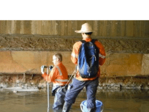
Sections of the Creek were dammed by cofferdams, and water was extracted and pumped to nearby industrial wastewater treatment plants. Sediment was removed, with large debris separated during excavation.
Sediment was then trucked to a treatment area where it was dewatered by gravity, with drained water again pumped for treatment. Sediment was stabilised with various mixture ratios dependant on the sediment section, but generally, 10% Portland cement, 10% steel slag, 10% local clay, and 10% fly ash was used and mixed mechanically. The stabilised sediment was transported to a constructed fill project for a dry dock shipyard, with ongoing monitoring for leachability due to infiltration of acid rain.
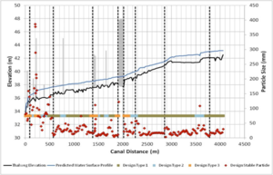
A number of practical issues had to be implemented to overcome restrictions in laboratories expertise, contractor experience and limitations due to access. Hydrological models helped determine the most stable residual sediment capping matrix, which included sands, gravels, and cobbles.